Media elements used in this module are protected by a variety of copyright licenses. Please use the "copyright terms" link associated with each item below for more information.
Click an image to view it at full size in a new browser window/tab.
credits:
© EUMETSAT 2007
copyright terms:
COMET Standard Terms of Use
description:
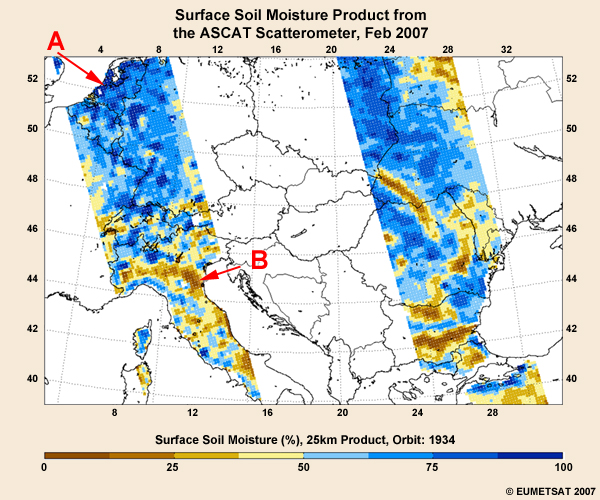
ASCAT soil moisture product for February 2007 showing the moisture content of 5 cm of the topsoil layer in relative units ranging from 0 (dry) to 100% (saturated) over east and west Europe
|
credits:
SAWS
copyright terms:
COMET Standard Terms of Use
description:
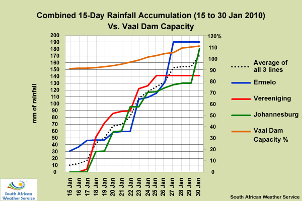
Combined 15-day rainfall accumulation vs. Vaal Dam capacity (South Africa), 15 - 30 Jan 2010
|
credits:
SAWS
copyright terms:
COMET Standard Terms of Use
description:
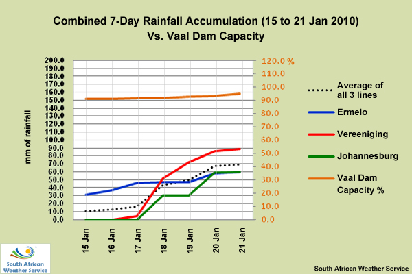
Combined 7-3ay rainfall accumulation vs. Vaal Dam capacity from 15 to 21 Jan 2010
|
credits:
SAWS
copyright terms:
COMET Standard Terms of Use
description:
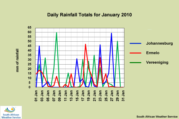
Graph of daily rainfall totals for Johannesburg, Ermelo, and Vereeniging South Africa from 01 to 31 Jan 2010
|
credits:
SAWS
copyright terms:
COMET Standard Terms of Use
description:
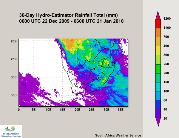
Accumulated rainfall based on SAWS's Hydro-Estimator over South Africa, Namibia, and Botswana from 22 December 2009 to 21 January 2010
|
credits:
South African Department of Water Affairs / NCU
copyright terms:
COMET Standard Terms of Use
description:
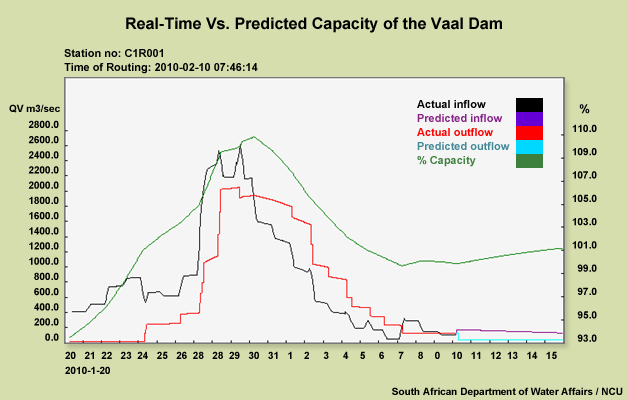
Hydrology graph showing actual and predicted inflow and outflow rates for the Vaal Dam and its capacity levels from 20 Jan to 15 February 2010
|
|

credits:
SAWS
copyright terms:
COMET Standard Terms of Use
description:
Provincial seasonal rainfall graphs for the Mpumalanga and Gauteng Provinces in South Africa from October 2009 to 21 January 2010
|
|
|
credits:
SAWS
copyright terms:
COMET Standard Terms of Use
description:
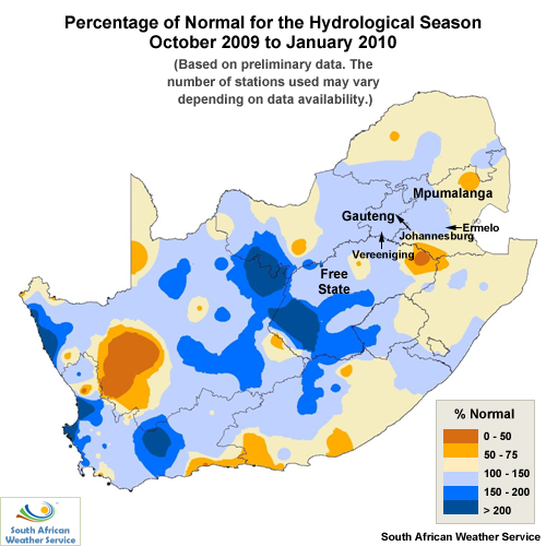
Provincial seasonal rainfall map showing the percentage of normal for the 2009/2010 hydrological season in South Africa
|
credits:
SAWS
copyright terms:
COMET Standard Terms of Use
description:
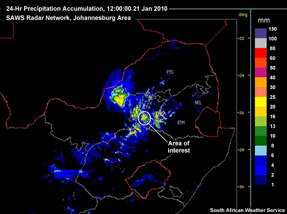
24-hour rainfall accumulation data from the SAWS radar network for the Johannesburg area on 21 January 2010 at 12Z
|
credits:
Google
copyright terms:
COMET Standard Terms of Use
description:
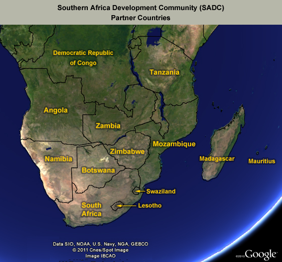
Map of Africa with the Southern Africa Development countries outlined
|
credits:
Institute of Photogrammetry and Remote Sensing, Vienna University of Technology
copyright terms:
COMET Standard Terms of Use
description:
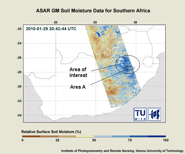
ASAR GM soil moisture map showing the percentage of soil moisture on 29 January 2010 in the Southern Africa region
|
credits:
Institute of Photogrammetry and Remote Sensing, Vienna University of Technology
copyright terms:
COMET Standard Terms of Use
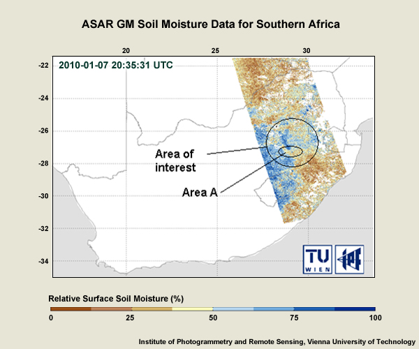
description:
ASAR GM soil moisture map showing the percentage of soil moisture on 7 January 2010 in the Southern Africa region
|
credits:
Google
copyright terms:
COMET Standard Terms of Use
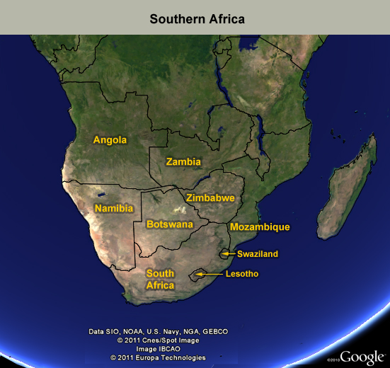
description:
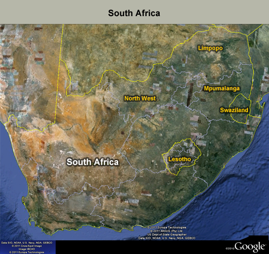
Google map of Southern Africa with the country names highlighted
|
credits:
SAWS
copyright terms:
COMET Standard Terms of Use
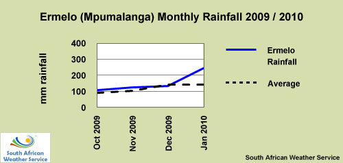
description:
Station monthly rainfall map for Oct 2009 to Jan 2010 in Ermelo, Mpumalanga Province, South Africa
|
credits:
SAWS
copyright terms:
COMET Standard Terms of Use
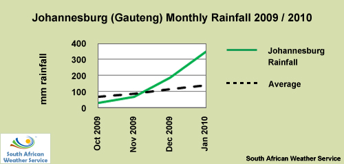
description:
Station monthly rainfall map for Oct 2009 to Jan 2010 in Johannesburg, Gauteng Province, South Africa
|
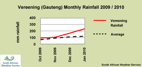
credits:
SAWS
copyright terms:
COMET Standard Terms of Use
description:
Station monthly rainfall map for Oct 2009 to Jan 2010 in Vereening, Gauteng Province, South Africa
|
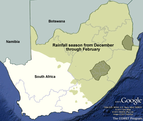
credits:
Google
copyright terms:
COMET Standard Terms of Use
description:
Map of the South Africa with the summer rainfall season outlined
|
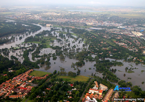
credits:
Aerovis Imaging / NCU
copyright terms:
COMET Standard Terms of Use
description:
Aerial photograph of the flooding of the Vaal Dam
|
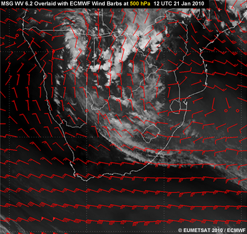
credits:
© EUMETSAT 2010 / ECMWF
copyright terms:
COMET Standard Terms of Use
description:
EUMETSAT water vapour 6.2 micrometer image overlaid with ECMWF 500-hPa wind field for 12 UTC 21 Jan 2010
|
credits:
coyright EUMETSAT 2010 / ECMWF
copyright terms:
COMET Standard Terms of Use
description:
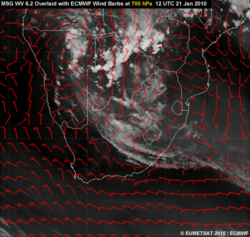
EUMETSAT water vapour 6.2 micrometer image overlaid with ECMWF 700-hPa wind field for 12 UTC 21 Jan 2010
|
credits:
© EUMETSAT 2010 / ECMWF
copyright terms:
COMET Standard Terms of Use
description:
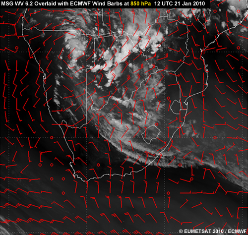
EUMETSAT water vapour 6.2 micrometer image overlaid with ECMWF 850-hPa wind field for 12 UTC 21 Jan 2010
|


